Written on August 26, 2011 at 9:05 pm, by Adam Cuker
Radar image of Hurricane Irene as of 8:47 pm CDT
3 comments
Hurricane Warnings are flying all along the mid-atlantic coasts,with already 2 reported Tornados
hitting a trailer park(easy tarket) seem to always hit trailer parks first.The main threat will be very heavy rainfall
high winds which will be blowing between the buildings in larger cities.And isolated Tornados in the New york area flooding will become a major problem has week end wears on.
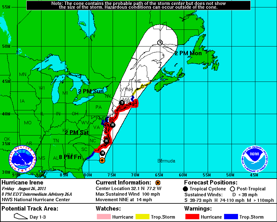
Hurricane Irene over land in eastern north Carolina-
Winds in excess of 75 to 80 mph are blowing around the eye of the storm,there has been tornado damage in
extreme n-e north Carolina.The storm movement is to the north at 15 mph and will make a second landfall possiblely near New york city early Sunday morning with very heavy rainfall and tropical storm force winds
in the north easts. stay tune too vortex chasers.net for the latests
Headed toward the New York with in next 5 hours Doppler rainfall totals around
10 to 12 inches eastern Va and northern north Carolana areas.New York will feel the full effects
of Irene between 9pm to midnite heavy rain flooding and tropical storms winds will continue though
mosts of Sunday..

3 comments
Hurricane Warnings are flying all along the mid-atlantic coasts,with already 2 reported Tornados
hitting a trailer park(easy tarket) seem to always hit trailer parks first.The main threat will be very heavy rainfall
high winds which will be blowing between the buildings in larger cities.And isolated Tornados in the New york area flooding will become a major problem has week end wears on.
Hurricane Irene over land in eastern north Carolina-
Winds in excess of 75 to 80 mph are blowing around the eye of the storm,there has been tornado damage in
extreme n-e north Carolina.The storm movement is to the north at 15 mph and will make a second landfall possiblely near New york city early Sunday morning with very heavy rainfall and tropical storm force winds
in the north easts. stay tune too vortex chasers.net for the latests
Irene
Headed toward the New York with in next 5 hours Doppler rainfall totals around
10 to 12 inches eastern Va and northern north Carolana areas.New York will feel the full effects
of Irene between 9pm to midnite heavy rain flooding and tropical storms winds will continue though
mosts of Sunday..
The comments are closed.